Modern sensors are good at flagging movement. Understanding what that movement means is engineering work. Geotech Assist combines deformation patterns, inspection records, geological structure, and historical wall behaviour into the same picture an experienced engineer would build, so the engineer reviews evidence, not exports.
Geotech Assist reviews the monitoring picture the way an experienced engineer would. That gives you a second pair of eyes on every signal, earlier indication of meaningful change, and your time back for the decisions only an engineer can make.
Geotech Assist reviews radar, prisms, inspections and geology together, so movement gets understood, not just alarmed.
Identify meaningful change before it becomes a critical alarm. Time to investigate, assess and plan.
Less time exporting, stitching and rebuilding context. More time on the decisions only an engineer can make.
In a typical monitoring setup, the engineer is the link between the data and the hazard picture.
Geotech Assist puts an AI layer in that gap. It aggregates the inputs, organises them around your active areas of concern, and identifies what is relevant to each one. You review movement, assess risk, and decide what needs attention.
The hazard stays front and centre. Engineering judgement stays in control.
Geotech Assist connects every monitoring source into one workflow, detects movement that needs attention, and keeps you in control of what becomes a tracked hazard. Three views, one decision loop.
Every morning the AI scans prisms, radar, InSAR, inspections, the geological model and historical movement. Where signals converge in the same place, it raises an Area of Concern with the evidence already assembled for review.
Two prisms are averaging 5.2 mm/day with an upward velocity trend. Ground-based radar shows a measurable increase in displacement over the same panel. An inspection completed within 100 m described tension cracks.
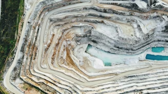
Velocity increased from 3.4 to 5.2 mm/day over the last seven days. The active area is in the foliated phyllite domain, the same domain as the 2024 wedge failure on the south wall. Recent inspection notes describe tension cracks.
InSAR shows 0.8 m/wk sustained line-of-sight creep over 14 days across a 200 m strip. No prism coverage in this sector. Inspection on day 7 flagged toe ravelling consistent with toe loss.
The strip sits in weathered diorite immediately above the planned cutback. Sustained low-rate creep over 14 days plus the inspection flag is the historic precursor pattern for the 2023 east-wall ravel. Recommendation is to prioritise four prisms on the panel to confirm the rate.
Single prism (BH-N-051) trending at 2.1 mm/day for 7 days, below the formal TARP threshold. No corroborating signal yet. Listed as Watch so it stays in front of the daily review.
Single-source signal in a domain with no prior events. Currently below the prism velocity TARP. Carry forward, watch for radar or inspection corroboration over the next 5 days.
Once a hazard is raised, the AI keeps the picture current every morning until it is closed. Velocity, TARP level, inspection findings, and the AI summary update in place so the file is always live.
The response level was raised yesterday after the velocity increase.
Velocity stepped up from 3.4 to 5.2 mm/day, with movement still concentrated on the upper bench. Radar corroborates the trend. Inspection notes describe tension cracks on the same structural orientation. TARP 3 controls remain appropriate.
Active for 56 days. Long-duration creep in the upper embankment. The AI tracks the InSAR rate, the piezo response to rainfall, and the weekly inspection.
Rate unchanged. Piezometric head rose 0.4 m after the weekend rainfall, consistent with the historic response. No change to TARP. Continue weekly inspection cadence.
Active for 9 days. Concentrated at the toe of Cut 7 above the new haul road. AI has been tracking the rate against the rolling 30-day baseline.
Rate has stabilised over the last 5 days. The active patch maps onto the F4 sheared zone. No corroborating inspection findings. TARP 2 controls remain appropriate.
Active for 38 days, now in monitoring-only mode. No measured movement, kept open because of the structural risk above the active haul road.
No movement detected on prisms or radar. Latest inspection clean. Continue daily inspection cadence given the consequence rating. Hazard remains open until the cut is benched out.
Define the question. The agent agrees the investigation scope, then works through the site data step by step so the engineer can see what is running before reviewing the output.

Walk through how Geotech Assist connects monitoring inputs, highlights areas of concern, and supports engineering review.